
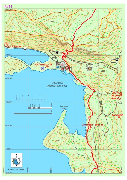
Kaş – Limanağzı
Lycia road goes from Çukurbağ towards south and descending from a terrace overlooking Kaş district in a perpendicular way and passes from Kaş settlement. Kaş district is a center in which needs such as public transportation, market, bank, accommodation etc. can be met. For the ones who will go on towards Limanağzı direction, they should move on with keeping in mind that there is no other settlement until Boğazcık – Kılınçlı settlement for obtaining the needed resources.
The road goes on towards the Büyükçakıl beach from an asphalt road parallel to the sea inside Kaş district and after passing the beach the road turns right and climbs towards the settlement area and then from there goes on as a dirt road. Before coming to Limanağzı area first Sebeda archaeological settlement is seen and after some little side passes with the help of the ropes in front of rock tombs overlooking the sea, some needs can be obtained from the businesses in Limanağzı bay. The pathway goes on among fields, stony areas and narrow dirt tracks in some parts and then turns towards the seaside again after a couple of kilometers from Limanağzı.
LİMANAĞZI (SEBEDA)
In this region which is named Bayındır port today the name of the town which contains Bahtsız and Kavgar hills is known as Sebeda. Town is set up around a secured port and it is a little farm settlement belonging to the Lycia period with its oil extraction workbenches, cisterns, rock tombs, sarcophaguses. There are Lycian type room tombs cut in natural stone dating back to 4th century B.C. at the slopes overlooking the sea of Bahtsız hill and at seaside there are the remains of buildings which can be related to the port usage and estimated to had been used as warehouses. At the hilltop there is an open air temple which is formed with the flattening of a natural stone on which there are sarcophaguses and niches. The ruins of the building over the Kavgar hill which can be reached with a pathway thought to be used in ancient times, is thought to be a watchtower. There are tombs around the watchtower belonging to Lycia and Roman period some of which containing inscriptions over them.


ANTİPHELLOS
The old name of the Antiphellos on which Kaş district center is set up on today, is mentioned as Habesos in the inscriptions in Lycian and on some coins. The city is known to have existed since 6th century B.C. had become a little settlement as the port of Phellos which is located just above it. However upon entering in Hellenistic period, Phellos declined and Antiphellos grew and become more important. This situation went on in the Roman period and the city was developed due to the cedar tree trade from the forests in the area and sponge fishing and became a rich city growing out of being just a port of Phellos and later became one of the members of Lycian League. Ancient city is located partly under current city and partly located on the peninsula lies in east-west direction. Hellenistic parapet remains which contain rectangular stone masonry workmanship on them can be seen at the section where the peninsula starts, from the side overlooking Meis Island and at seaside. The theatre overlooking the sea of the Antiphellos near the road reaching to Çukurbağ Peninsula has been preserved very well until today. Theater is located in a relatively higher place with its 26 seating rows and beautiful stone masonry work and has the typical Hellenistic theatre properties but it does not have a stage building.
At the northeast of the theatre, there is a tomb room on which 24 small women figure dancing holding hands reliefs are placed and dated back to 4th century B.C. carved from natural stone. Most of the tombs in Antiphellos are located above the houses located at the sides at the north of the city or above them. These tombs are some of the best examples of Lycian rock tombs with their side workmanship and inscriptions on them.
The most important monument of Kaş is the sarcophagus dating back to 4th century B.C. which is consisted of a single block on the Uzun Çarşı Street. The sarcophagus has been preserved rather intact until today and has bead motifs and some inscriptions on the lower section of 150cm in length. There is a figure of a sad man crossed one foot over the other, leaning on his staff, half clothed and a woman at the left on the northwest pediment. At the southeast pediment there is a standing woman in a coat. At the both sides of the lid there are lion reliefs with their heads between their paws.
BAYINDIR-ASARGEDİĞİ HILL SETTLEMENT AREA
Kaş district is located at the southeast of Bayındır village at the Asargediği hill settlement area east of Limanağzı. When climbing towards the slopes from the flat areas east of the settlement; first a structure with square planned walls of clear cut stone masonry which may have belonged to a tomb monument can be seen. Necropolis area, in which Lycian type sarcophaguses belonging to Roman period are located, lies in the direction of east-west until it reaches to hilltop going through the sloes in the settlement. There is a defensive complex at the hilltop which is built using rubble stones in general and cut stones in some parts and of which walls were supported to the main stone. No detailed information could be had related to the planning scheme of the structures due to the dense vegetation. A trapetum sink belonging to workshops are now split in half.