
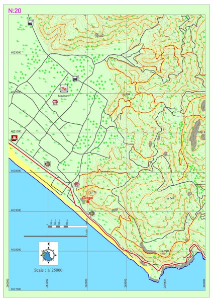
Mavikent – Karaöz
The entirety of the Lycian road within this section progresses on the coast in parallel fashion to the sea. On the coast, in the south of the Mavikent settlement, the settlement of Gagai and aqueducts can be seen. Even though the section legend includes markings indicating a grocery or settlement, it is highly probable for the settlements within this section, especially the ones on the coast, to be empty during the winter since these locations are generally inhabited during the summer for vacation purposes. Particularly, the stores for food and water can be accessed in the summer.
GAGAI
Gagai, which is located within borders of Mavikent Town in Kumluca District, Antalya Province, was established on the hill at north of the white limestone mound on the beach, the skirts of this hill and the plain in front of it. The name of the settlement is referred to as “Palaion, Teikhos or Old Castle” in ancients sources.
While most sources cite that the city’s name was derived from the word “ga” which meant “earth” in Doric, or that it was derived when a Rhodian commander named Nedius came into danger with his ship after winning a battle against Lycian and Cilician pirates and his crew shouted “ga ga” upon seeing the land, it is presumed that the name Gagai was derived from the word “hahha” which is spelled “gaxe” on coins with Lycian inscriptions and which is originated from old Anatolian languages.
It is also said that the city was given its name due to the river Gages nearby and the lignite mine named Gagates which was also nearby. Gagai was represented in the Lycian League through its union with Rhodiapolis and Corydalla, of which Corydalla was the leader. The city, which is frequently cited in sources from the Roman period, was donated money by Opramoas for the construction of a bathhouse. Gagai was also one of the first cities to coin its own money and its first coin was minted during the classical period. Due to the figure of Athena that was present on the city coins, it is presumed that the holy goddess of the city was Athena.
Gagai, which was inhabited from the classical-early Hellenistic period, expanded in the Roman period and mant structures were built on the skirts of the hill and the surrounding plains. The city consisted of the acropolis, lower acropolis, city center and the necropolis areas. The acropolis of the city was on a hill from which the land and sea routes could be easily controlled. The acropolis also included the structural remains that belonged to the earliest period in the history of the city. The walls of the rectangular castle in the acropolis belong to the early Byzantine period. There are also the ruins of a castle which was built in the Hellenistic period within this castle. The tower is at the highest point of the city which also has the fullest view of the city. There are the remains of a 5th century church at the west of the acropolis.


The lower acropolis is on the first hill that is over the sea level. The walls are presumed to have been built around the 6th or 7th century against the first Arabian attacks. The tower, of which the remains are located within the lower acropolis, is dated back to around 10th or 12th centuries. The plains on the west and northwest of the acropolis form the center of the city of Gagai. Public structures such as the bathhouse, theatre, aqueduct and the building presumed to be Nymphaion are on these plains. However, the damages suffered by the structures make it impossible to go beyond guessing as to what their functions are. The necropolis of the city is on the rocky cliffs on the northern slopes of the acropolis. The tombs exhibit features relating to the Hellenistic and Roman periods. No tombs of the Lycian type have been encountered.